Saturday, December 24, 2022

Kirkwood, Skiing #4

My rib still hurts, and the car is still in the shop. There were issues to be resolved and they are yet to start working on the repair. I obviously won't get it back before Christmas, but I wanted to go back up the mountain at least once before. I need a car for groceries and other things before Christmas as well, so I rented a car for a couple of days. I ended up with Honda Civic from Dollar.

On Dec 21, I took it to Kirkwood through winding road. At first, the car felt primitive. Press the pedal, and it would make noise. But it wouldn't go. I haven't been in a gas car for a few years now and I'm no longer used to it. After a while though, it became fun. The light-weight car was infinitely toss-able in the mountain road. I was driving 60 through the winding curves. Much more fun than the interstate cruiser known as Tesla Model S. I was reliving my 20s as such. I used to drive to Kirkwood from the Bay Area in my Integra. I'd be driving like a maniac through the darkening evening, anxious to get back home after a long day of skiing. 

Lunch Break at Sunrise Cafe

Skiing itself was a blast. The snow wasn't as nice as a week ago, naturally. The groomed runs turned icy at places, thanks to snowboarders scraping the hills. But ungroomed off-piste slopes still have plenty of soft moguls. After warming up on Solitude, as I used to 20 years ago, I stayed on Sunrise chair most of the day. When the backside became shady, I came back to the Solitude. The ridge -- I think it was called Eagle -- to the front side off Sunrise was rather bare. So, I skied down to Iron Horse and then came back to the front. It was just like the old days.

The next day, we went to pre-Christmas lunch at Yum Chinese Buffet and stuffed ourselves for 2 hours. In the evening, I drove the car back to the airport and dropped it off at Dollar. In all, I was up and running for 2 days after skiing. Then, the PEM bus arrived, and I crapped out in the afternoon of the 3rd day, for about 10 hours. I was then up and running again. 10 hours of PEM after hard skiing is not bad at all. The hard skiing probably required 3 days for recovery. But I still was flush with dopamine for 2 days, and that probably doused the PEM. And, when dopamine finally ran out, I crapped out.

Thursday, December 15, 2022

Northstar, Skiing #3

There is such a thing as too much of a good thing. Some parts of the slopes haven't been skied on; the snow was still fresh. The moguls on the heavily skied on portion of Zephir were bigger. But the heavy snow made it slower and therefore more skiable. I stayed on Zephir most of the time, again. 


I managed to postpone the car repair till Wednesday. Then I was on my way back to the mountains on Tuesday. The snowbanks by the road were 6 feet tall, but the roads were fine. One day respite must've been enough to melt whatever's left after the plow shoveled aside to the shoulder. I stopped at Truckee Tesla station, took care of the morning business while refueling, and then I was on the yellow lot like the last time. I carried my backpack with lunch this time, got on the shuttle bus and I was on the slope by 10 AM. 

On the 2nd run, the tip of my skis got caught in a mound and I fell forward. One of the poles got stuck in the snow and impaled my ribcage. I'm not sure if the rib got bruised or broken. I've been in pain since and unable to breathe deeply. It felt a little better yesterday, then I sneezed and got stabbed by a terrible, sharp pain. Now I'm feeling worse.  I hope I'll back in shape to ski again by the time I get my car back. 

The moguls were more difficult, and hence progressively better for practice, than the last time. I was getting my rhythm right, up and down as well as side to side. Maybe this is the year that I finally mastered moguls. I'll have to move on to something else then, perhaps to powder skiing.

The aftermath followed the same as the last time: brief struggle with fatigue and sluggishness in the afternoon, 2 days after. It's more like delayed post-exercise fatigue. If the season progresses like it did last year, this pattern of post-exercise fatigue should continue throughout December, and then turn into post-exertional sickness in January.


Sunday, December 11, 2022

Northstar and the Aftermath, Skiing #2

Skiing was fun once again. The latest storm left 3 ft of snow in the mountains and the packed snow supplied enough grip for control. To boot, Northstar had lots of intermediate/advanced slopes with small bumps that are perfect for mogul practice. 

Kirkwood had more snow and that is where I wanted to go. But then I remembered how slick the mountain road was 5 days ago after the second storm. I attempted to get to Kirkwood on 12/2, but I had to turned around at Pioneer just before Hwy 88 plunged into a dark ravine. The car already started to slip a few miles back, and the shaded downhill wasn't going to help the matter. I figured $5k damage that I incurred back in September in New Mexico was enough. Kirkwood will have to wait; I'm not going there till the weather has been clear for at least 2 days.

I got to Northstar around 9:30 AM after stopping for a quick charge in Truckee. But the parking lot was so far away from the lift -- you have to take shuttle to get to/from the lift -- it took me another 30 minutes to get on the slope. There were paid lots close to the lift, but I wasn't the one to shell out more fees on the top of $430 that I already paid for Epic Pass. Had I known that the parking was so far, I would've taken my backpack to carry my lunch with me. I had to take the shuttle back to my car for lunch, and I'm sure that took up another 30 minutes. 

I managed to squeeze in 3 skiing sessions of about 4 runs each. The runs were at least twice as long as those at Soda Springs (I had to take 3 breaks on each run off Zephir chair), so a session of 4 runs in Northstar is at least equivalent to 8 runs in Soda Springs. At the end of the first session, I took Comstock chair to the summit. That one required 5 breaks to get down.  It was 2 PM when I was back on the slope after lunch, and 4 PM when I was all done.  I came home after dark.

The aftermath followed the typical pattern. The next day, I was up and running, flush with dopamine. Then fatigue and struggle followed before mildly recovering the 3rd day, enough to squeeze in 4x1 block jogging. Today, I'm struggling with heavy fatigue from the jogging. I probably should've given full 3 days of rest instead of jogging.

Overall, it's an improvement over the aftermath of the first skiing on 11/14, which was within the 2-week probationary period after the flu shot. So, now I'm concluding that the subpar performance after the first skiing was due to the flu shot, not due to weaker novelty effect after 3 seasons of skiing. I should do fine throughout December. Then I'll half the amount and difficulty. Then again, I may not have to. I can ski three different resorts in CA with Epic Pass, so I may be able to keep the novelty effect alive throughout the season by rotating the resorts each month. If I make it to Park City, Utah, I may keep going full power well into April. We'll see.

Another storm just dumped 4 feet of snow and I should be going up the mountains again. But I have to take my car in for repair tomorrow, and it'll take a week to get it back. I'll see if I can postpone the appointment to Wednesday so that I can go back to Northstar on Tuesday.


Saturday, December 3, 2022

15-mile Bike Ride

The 2-week probation period after the flu shot on 11/5 was over two weeks ago. On 11/30, I figured I'd be fine with bike riding, so I went on a ride intending to go to Discovery Park. I was knocked out just a day before, after walking from Tesla station to Barns and Noble and spending an hour walking about at the bookstore, but that was probably because I walked after jogging the day before. Biking 5 miles after a day of rest should be fine.

As I often do, I went over. I felt great when I got to Discovery Park, so I decided to continue on. I ended up at the trail near REI, and then I continued till I came to an access to the river. I poked around the river for a while and then returned, for the total of over 15 miles. The next afternoon I got knocked out. But I was back on my feet in the evening. It was one of the shortest post-exertional sickness.

When I biked 14 miles to REI on 10/24, I was knocked out for 3 days. post-trip probation of 2 weeks starts one week after returning from the life on the road, and that bike ride was right in the middle of that probation period.  I got sickened again this time, but only for half a day. 

Overall, not bad. Especially given that it was right after getting knocked out from jogging and then visiting the bookstore. And it was at a decent clip: Nonstop to the river and 130 minutes in total including two breaks. I should give 15-mile ride another try after at least two non-sick days.

Thursday, November 17, 2022

Kirkwood Aftermath

The day after skiing,  I was up and functional. I was tired, but it was a normal post-exercise fatigue.  On the second day, however, I keeled over and struggled. It was the first skiing of the season and the Novelty Effect there should've protected me from post-exertional sickness. I blame it on the flu shot that I got on 11/5. I was already struggling with the effect of flu shot before I went up the mountain -- I was keeling over after 4 x 1 block jogging that I was able to handle prior to the shot. I figured I might be able to overcome it with Novelty Effect from getting on the slope for the first time in the season. I obviously didn't. 

The effect of flu shot should last no more than 2 weeks and I should be out of the woods in a few days. So, the next time I should be able to stay out of post-exertional sickness. If I do, then I'll conclude that the flu was the culprit. If I don't, then it could be that the Novelty Effect is not as strong this year, after 4 seasons of skiing. 

Tuesday, November 15, 2022

Kirkwood, Skiing #1

To be fair, it was over 15 years since I've been here, and that could be why I don't remember much. Only thing I remembered was Timber Creek Lodge where I used to park, and I misremembered it as Beaver Creek Lodge at that. But I've been here so many times, I would've remembered the main lodge once I saw it. I think things changed and that is probably why I don't remember any of it. The main lodge, and the plaza above it, was probably built in the last 15 years. So are the condos and rentals spread out between Timber Lodge and the main one. 

But I did remember the water tank on the side of Solitude run. Solitude used to be our warmup run in the morning. About halfway down on the right was the water tank. Greg Lynn, one of my colleagues from Novel days, once commented how my knees were glued together as we ski past it. Skiing has changed since -- parallel skiing is out, carving is in -- and I had to relearn since I came back.


I didn't remember anything of Hwy 88 between Kirkwood and Jackson either. I can't hold my memory accountable for it though. It is the mountainous portion of the highway and there is nothing remarkable on it. I do remember the Central Valley portion to Stockton and I probably would've recognized it if I drove through it. But I turned north toward Sacramento from Jackson, so I didn't get to see it.

It was my first time in the last 15 years. I ought to be excited, but I wasn't for some reason. Maybe it was the effect of the flu shot. I still have one more week to go to escape the physical depression from it, and I was under the weather from the effect of the jogging 2 days ago. The snow condition probably didn't help. The icy base was covered with granular powder that made it hard to control the skis. It just overly tiring, even for the first day of the season. I went up Cornice chair at the end of the morning runs and I had to lie down in the snow in middle of the run. I don't think I'll come back to Kirkwood till it gets more snow. Maybe then it'll look more like the Kirkwood that I used to know, with thigh deep snow on the Eagles run on the way back to the lodge from the back side of the mountain.

Saturday, November 12, 2022

Post-Flu Shot Struggle

The COVID-induced social distancing kept flu at its bay for 2 years. Now that people are out roaming freely, the flu is back, and the season is turning out to be a bad one. Flu activity is extraordinarily high. They are calling it a triple pandemic of COVID, flu and RSV. I'll be active this winter, thanks to my Epic ski pass. It's likely that flu and I will cross the path at some point, so I figured a flu shot would be a good investment. I walked a mile to Safeway pharmacy and got one for $33 on 11/5.

The next day, I keeled over. I bounced back the day after and went for 4x1 block jogging. I keeled over again the next day. 4 days later, another jogging and another crash. I was able to do 4x1 jogging prior to the flu shot. It seems that the flu shot lowered my exercise tolerance and I'm now crashing regularly. I'll have to hunker down for the next 2 weeks till the storm blows over.


Sunday, September 4, 2022

Outer Banks

It's been a long drive. I left Lewes early in the morning of 9/2 and it was 5 PM by the time I crossed the Virginia to NC. I was pretty tired by then. Then Arby's in Moyock said "best burger in North Carolina" and I felt an immediate lift of my mood. I haven't lived in NC for ages -- Harris Teeter was still named Big M and Food Lion was Food Town when I was here -- but it still felt like home. It is just a psychology, to be sure. There is no difference between Virginia and North Carolina that one could discern without looking at the signage and yet you feel different when you know you are in one and not the other. It's like Christmas. There is no difference between 23rd and 24th. The sun is at about the same place in the sky and nights are as cold. But eyes are aglow on the night of the 24th in anticipation.

After the usual morning routine at a McDonald's just down the road from China Buffet in Lewes/Rehoboth, I stopped at Rehoboth Ave, walked around for a while and then visited Rehoboth Beach. Then I followed the Coastal Highway to Ocean City, MD on my way to Norfolk, VA. Along the way were more beaches -- Dewey, Bethany, Fenwick -- and Assateague Island that straddled Maryland and Virginia. I stopped there and spent an hour in Assateague Island National Seashore after renewing my America Beautiful Pass there. It expired in July and I'd needed a new one since I'm stopping at more national parks on the way back to West. Assateague Island looked a lot like Tawas State Park with the strip of sand bar stretching out into the water. They are fused together in my memory; I can't tell if I'm remembering Tawas Point or Assateague Island. 

It was getting late in the day by the time when I crossed the Chesapeake Bay and arrived at Norfolk. I thought maybe I'd stay in Norfolk and explored the city. But there wasn't much to do in Norfolk; I was done after the Naval Museum and USS Wisconsin. So, I pressed on to Outer Banks and arrived at Kitty Hawk at 7 PM. I walked around in Kitty Hawk beach for a while and then bedded down at the Tesla station in Kill Devil Hill. I don't remember where I ate for dinner. I might have bought groceries at Harris Teeter where the Tesla station was located in. 

The following day was another long one sweeping through the Outer Banks starting from Jockey's Ridge. Jockey's Ridge, like just everything in Outer Banks, is a gigantic sand dune from coast to coast. It is probably the tallest and largest one in The Outer Banks. From the top, you can see both Roanoke Island in distance and Atlantic Ocean. I hiked from the entrance to all the way to the inland shore. 


Roanoke Island, a stone's throw from Jockey's Ridge, was a disappointment. My search for the Lost Colony took me all the way to Elizabethan Garden, but it appeared that they turned the Lost Colony into a theater that was closed. I had spent enough time on the Island by then; I turned around and came back out to the Outer Banks. Then the long march to Ocracoke Island commenced.

I had to pull over when I saw a large white sand bar on the Atlantic coast as I crossed Bonner Bridge to Pea Island. I parked on the Oregon Inlet and then walked over the dunes to the wide open beach on the coast side. It was one of the beach beaches in Outer Banks.


I no longer remember where I got stuck. It could be somewhere on Cape Hatteras National Seashore. Or maybe it was on Ocracoke Island. I poked around as I drove down the narrow strips of Outer Banks and walked around the beach a few times. Then I pull off to the side of the road not knowing that it was a quick sand. There was no getting out of it without towing. The Honda in front of me was stuck too and a tow truck arrive to get it out. The driver wanted $150 to get mine out while he was there. I hesitated and he was gone. They must be making a killing rescuing the vehicles there. A cop and good Samaritan stopped, struggled for about 30 minutes and finally got my car out. The wheel well cover came off in the process and I had to drive taped up for the rest of the journey. 

It got to Cape Hatteras Ferry Terminal at 4 PM. I remember it was 3 PM when I stuck -- I was watching the time so see if I can make it to the ferry -- so it I must had stuck on Cape Hatteras, not Ocracoke. There, an agent told me that the last Ocracoke ferry might have been cancelled. It was too late and I couldn't have made it anyway even if it wasn't cancelled. But it was an excuse I could use to spend the night on Ocracoke Island. I think I checked out a motel when I got to Ocracoke, only to find the rate exorbitant. I spent the night in the parking lot of Ocracoke Campground. 

I spent the evening at the beach. Then I took a bath in a secluded spot, ate my dinner of instant ramen cooked in my frunk, and then climbed on the back of my car. A sheriff came by at night and knocked on my window. I told him that I couldn't make it out of the island because the ferry was cancelled and there was no campsite available. He apologized for waking me up and moved on.

I took the 7:30AM ferry out of Ocracoke. It was a long ride to Cedar Island that took 2 hours. Then it was a nonstop march to Raleigh, and it was past 2PM when I got to my sister's house. They were out of town, but I got in through the backdoor and spent the next day resting.


Thursday, September 1, 2022

New Jersey Coastline to Lewes, DE

Lewes was a good-sized town. The official population is only about 5,000 for both Lewes and Rehoboth, but the Coastal Highway that runs several miles from Lewes to Rehoboth Beach is bustling thoroughfare lined with businesses. And I somehow thought it was a village with only a ferry terminal and not much else. Again, the imagination didn't match the reality.

I picked up the car from my sister's house in New Jersey around 7 PM and then drove about 20 miles south to Tesla station in Clarksburg in a Wawa station where Tesla chargers were located. Wawa is a familiar looking place by now. They are all over Pennsylvania and New Jersey and they all look the same just like Sheetz in Pennsylvania or Sinclair in Nebraska. It was getting dark by the time I got to the Wawa station, and I don't like driving in the dark. In the dark without any visual queue, you get no idea what the locale looks like and therefore no understanding of geography. In more scenic roads, you miss out on the scenery as well. So I plugged in and climbed into the back of the car at Wawa instead of continuing on. The shed behind the charger must've been some kind of electric station; it was making loud buzzing noise. I had to get out later and move further away to get some peace.

The plan for the return trip to CA was to sweep through the coast down to Jacksonville and then cut across Florida to the Gulf side. I would then again sweep through the panhandle of Florida, Alabama and Mississippi before heading straight to the four corner states. I might stop and Big Bend National Park in Texas if time allows. So, todays plan was to drive down New Jersey's barrier islands on my way to Norfolk VA. Long Beach Island would be the starting point of the long coastal sweep.

You'd think NJ as suburb of New York and Philadelphia. You'd be right if you look at just the Northeast and Southwest portion of NJ. But large chunk of the rest is forested. To the north is the remnants of Appalachian Mountains. A part of Appalachian trail actually goes through New Jersey. To the south on the way to the barrier islands on Route 72 is the coastal forest on sandy soil. I took that rather scenic and idyllic route from Clarksburg to Long Beach Island.

Long Beach was a beach resort town. I parked across Drifting Sands Oceanfront hotel, which looked more like condos than a hotel, and then walked to the rather idyllic and empty beach. It was still early in the morning when I got there. I took a few photos and then moved on to Atlantic City.

It must've been decades ago, and I no longer remember when and why, or with whom. But I do remember being on the boardwalk in Atlantic City once. It was on my way, so I might as well stop and see if I can recall something from the previous visit. I took US-30 into Atlantic City and then stopped at Golden Nugget, used their restroom and took a few pictures at the marina across the hotel. Then I drove to the boardwalk, parked by Hard Rock and then walked the boardwalk. the Boardwalk had Caribbean theme with tiki bars and pirate motif. I don't remember any of that. But the shops lining the boardwalk felt familiar, probably not because of I remember any of them, but that is what all boardwalk looks like. 

From Chambersburg to Gettysburg, Pennsylvania was a burg-city. From Atlantic City on down along US-9 was Ventnor City, Margate City, Ocean City and so on. The Jersey shore was city-city. I followed  this series of beach towns, all the way to Ocean City. It was a September afternoon, but it still felt like summer. I had to stop just about every beach and take it all in. 

Ocean City

The drive from Long Port to Ocean City across the bay felt like a warmer version of SF bay. Ocean Drive Bridge looked just like San Mateo Bridge too. Lots of beaches lining both shores. I had to make another stop when I saw the wide sand bars at the end of the bridge. I pulled into the parking lot on the other side of the road and walked all over the sandy bar there. Then I went to the boardwalk of Ocean City and took some more photos the beach scene, with the Ocean City skyline as the backdrop. I have to say that Ocean City is a better location than Atlantic City to visit unless you prefer to Casinos at Atlantic City.


After Ocean City, I turned on to Garden State Parkway to Cape May where I planned to take ferry to Lewes DE. I got to the ferry terminal at around 3 PM, but the next ferry wasn't till after 4 PM. The ferry would've added $60 to the cost as well, so I wasn't going to save time or money by taking ferry. It still would've been nice to cross Delaware Bay on a ferry, but the cost and time wasn't worth it. So I decided to go around the Delaware Bay through Wilmington. The detour would add 3 hours to the trip, but I'd arrive at Lewes at about the same time as I'd if I took the ferry.

I didn't stop at Wilmington. I thought for a moment that I'd sleep in Wilmington and explore the town in the morning while I was there. But I still had too much light left and there wasn't much to do in Wilmington. I pressed on to Lewes leaving the nagging feeling that I'll never be here again.

The town of Lewes itself was a nice resort town along Old Mill Creek that harbored a marina. Something was going on when I got there at 6:30PM, and the street was jampacked. I meandered through downtown Lewes and then got to Lewes Beach. I spent some time there taking pictures and then took an outdoor bath at the Beach Patrol building. It was time for dinner then. I drove out to China Buffet off Coastal Hwy and then slept in the parking lot there after the dinner.


Wednesday, August 31, 2022

August in NYC

Been here, done that.  It's now 4th time in NYC since 2017. That probably explains why I'm not as excited as I did before. 

I slept over in a motel in Monroe Township before leaving my car at my COVID-phobic sister's house in NJ. I just dropped off my car, stuffed everything I need in my 65L backpack and then I was on the bus to NYC. I had to carry the tent -- the floor leaked in the rain at Cirque of Towers, and I had to return it to Big Agnes -- and it added weight and took up a lot of space in my backpack. I bought my 1-month pass at Port Authorities terminal and then took subway to 83rd Street apartment that I rented for a month for $2900. I knew NYC like a local by now; nobody would've suspected that I was a visitor if it weren't for my backpack. My ex flew in and joined me a few days later.

Greenpoint, Brooklyn

A few trips -- the long walk to Washington Heights, grocery run to Flushing, and Green Point -- between attending open houses stand out in my memory.  The main purpose of the visit was to check out the real estate market, after all, so I scheduled viewing properties at least once a week. I don't remember much other than that. And the time just flew by unlike 2017 and 2019 when NYC was still new. The brain speeds up things when things are not new.

The three-weeks probationary period was still in effect though. I was walking about without keeling over the next day, till I went down on the 21st, exactly3 weeks after I arrived. We went on the trip to Green Point on the 20th and walked a lot. We walked all over Long Island City and then took the bus to Green Point. Then we walked down Franklin Street and then walked back up Manhattan Street to meet my nephew Eric who was in town to visit his friends. We walked down Manhattan Street again then back up to Green Point station where we split up with Eric going to NJ to see his friend. I struggled to stay up the afternoon next day. Then I keeled over again a few days later after I walked Chinatown and Tribeca starting from 28th Street. After that, I was back on my feet. I walked long walk every other day: Kew Garden; from Brooklyn Downtown to Grand Army Plaza; from Sunnyside to Elmhurst and then Forest Hills. The pattern followed familiar J curve: up and running for 3 weeks, struggle for a week or so, and then bounce back up. Then it was time to leave NYC.

NYC still is a fun place, to be sure. There are tons of things to do, places to visit and eateries to, well, eat. But it's no longer the magical place that it once was. I don't know if the novelty will continue to fade out. Maybe it won't; the novelty may simmer on rather than scintillate as it did the first two times.  Like I'm a local rather than the first-time visitor. Still, I may need to rethink about buying a property in NYC. Once the magic wears off, it's people, not place, that keeps you alive and awake. And it's not as easy to make people connections in the city than in the countryside, especially if you are not working.

Sunday, July 31, 2022

Harrisburg

Last year, I came in from East, from Pittsburg, via a half dozen burgs. This time I approached Harrisburg from north, perpendicular to the Appalachian creases and following the Juniata River.  It created a new layer of Harrisburg in my memory. The two layers of Harrisburg had to be connected to make it a whole. Otherwise they'll remain separate and unrelated, like Madison. And the nexus between the two was the Susquehanna River. I walked to the river from the Capitol last year, and I crossed the river to the north of downtown this year.

I didn't leave Elyria until after 1 PM, and I got to State College at almost 6 PM. I plugged in the car first and then walked around Penn State. It was 7 PM, past dinner time, when I was done. I drove to Kimchi but it was closed. I drove back to College Ave and settled for a hole-in-the-wall place named The Koop and had bibimbap there. Then I finally crossed Susquehanna River to get to the Harrisburg supercharger after 9 PM. I plugged and slept there.


I drove back to the Susquehanna River in the morning. McDonald's was conveniently located on Front Street, at the north end of the city, for the morning coffee. I took the coffee to Fort Hunter Mansion Park north of it for breakfast. Then it was matter of following the river to the state capitol in the south where I was the last time, to connect today's Harrisburg with the last year's. Afterwards, I drove through Harrisburg downtown on the way to NJ. That done, I now can say that I understand Harrisburg.

Saturday, July 30, 2022

Toledo to Elyria

I had no concrete plan and I was playing by the ears by now. I've been all over the Midwest last year and I was not going back to where I've been. Which meant I'm not going south to Columbus, or east to Cleveland. But I haven't been to Ohio's coastline between Toledo and Cleveland. So, I decided to sweep through the lakeshore towards Cleveland and then head to New Jersey from there.


There wasn't much on my plate this morning other than checking out the Toledo downtown and another place or two of interest.  I first drove to the Museum of Art, walked around a bit, took a picture and then went to the downtown along Maumee River. I parked the car on Summit Street and walked Monroe Street toward the river. I ended up at Cornings headquarters and walked its trails by the river and circle out back to Summit Street. I then walked along Summit for a while and then was back to the car.  And that was that for Toledo, a middling city in Ohio. 2 years ago, I didn't know anything about Ohio. Now I can say I've been to all the cities -- Columbus, Cleveland, Dayton, Cincinnati, Akron and now Toledo -- in Ohio.


Shortly after leaving Toledo, the tire pressure warning went off. I stopped to check, and it was visibly flat. I wasn't having a good luck with tires; it was the 3rd tire leak in 2 years. I stopped to pump the air at a Speedway station in Northwood. It took my $2.50 but didn't pump. They only gave me back $2. I drove across the road to another station, and the casher told me I could get a free air at a tire store on Navarre Ave. I ended up spending a good hour chasing air in Northwood, and then was finally off to Sandusky.

On the way was a series of beach towns. Port Clinton in particular appeared to be a working class resort town. I grabbed a sandwich from Wendy's and drove across the street to the waterfront for lunch. I walked to the lighthouse afterwards and then I was back on the road after 2PM. I stopped briefly at the beach to take a few photos. I then made an attempt to get to Catawba Island State Park, but I turned around. I no longer remember why; perhaps I was running out of fuel or I had to pay to get into the park. 

By the time I got to Elyria in the suburb of Cleveland, the tire was getting flat again. I had to pull over for more air. But it was going to keep losing air, and I had to get it fixed. I first stopped at Firestone, but they were closing in an hour and they couldn't look at it.  I then stopped at a few more tire stores, but none could deal with Tesla. Good thing they couldn't: it wasn't fixable anyway. When I got to Walmart, they told me that the tire cracked and needs to be replaced. They didn't the right tire, naturally, and I was stuck. It was getting late, and tire stores were closing. I called around and Mr. Tire in Northridge finally said they could get a pair the next day, so I placed order. I then drove to Mr. Tire store, pulled into the back of the building and slept there.


The next day, it was going to be several hours before the tires arrive. I wasn't comfortable with Cooper Tires, a brand that I'm not familiar with, either. So I placed more calls in the morning and found that Firestone, the first store that I stopped at, had tires available. I cancelled my order -- Mr. Tire folks not only let me out of the deal, but they also put more air on my gimpy tire so that I can limp along to the next store -- and drove to Firestone. They happened to have sale on QuietTrack, the top-rated tire for Tesla: if I buy 3 tires, they would get me the fourth for free. I only needed 2, but I figured I still break even with set of 4, given the 80k mile warranty on them. Eagle Touring that I had on my car had only 40k mile warranty and I used up half of it already. One was leaking and another was bold, on top of it. 

When it was all said and done, it was 1PM and I was out of $1,000.  But I was finally on my way to New Jersey. And it felt good not to be limping anymore.

Thursday, July 28, 2022

Mackinaw to Saginaw: Tracing 2017 Route in Reverse

The bathroom is in the building by the water. The entrance to it faces the water. I was here at Presque Isle only once 5 years ago, and yet I remembered. The memory buried deep in the brain came gushing back as I approached the harbor on Grand Lake Road, and I started looking for the tackle shop and deli on the left of the road and the marina to the right. It was as if I was here just yesterday.

I was going take the freeway and go down the middle of the Lower Peninsula toward Lansing. Back in 2017, we drove up US-23 from Saginaw to Mackinaw, and I'd rather take the road not taken before. A few minutes into it, I changed my mind. Sweeping down the coastal for the second time, or anything for that matter, would be better than the boring inland freeway. I exited I-75 soon after I left Mackinaw and headed to Cheboygan. From there, I followed US-23 all the way to Bay City where the Tesla station was located.

As soon as I got to Cheboygan, I looked for the campground that we stayed overnight in 2017, but I couldn't find it. It turned out Robert's Landing Campground was halfway between Cheboygan and Mackinaw City. I missed it because I took detour through I-75. 

Huron Beach, Preque Isle, Tawas City. From Cheboygan, it was a walk down the memory lane. The road never looks the same in the opposite direction, but I managed to find most of the locations that we stopped in 2017. Some places changed. Boneyard BBQ, and its dancing pig sign, at Tawas City was gone and was replaced by another eatery. I stopped at Tawas State Park that we skipped in 2017 because the car didn't have enough range. And I'm glad I did. It was a vast sand bar stretching out into the lake encircling Tawas Bay. It was larger version of Sand Point Beach in Pictured Rock National Lakeshore.


I must have stopped at Bay City supercharger 2017: it was the last supercharger in the Lower Peninsula and the next one was in Luddington on the other side of the peninsula several hundred miles away. But I didn't remember the Telsa station there. The similar look of the charging stations must've turned my brain off; it's the wonderous new places that you remember, and Tesla stations isn't one of them. From there, I continued on US-23 to Toledo skirting Flint and Ann Arbor and bedded down at Red Roof Inn after recharging the car in Maumee.


Wednesday, July 27, 2022

Michigan Upper Peninsula

In 2017, we wanted to cross Mackinac Bridge and go north to follow RD drive #61, Upper Peninsula Drive. But there was no Tesla supercharger in the Michigan's Upper Peninsula. There wasn't too many in Lower Peninsula either, but we still managed to make it from Saginaw to Mackinaw by refueling at Tawas City where we had lunch and lounged at the beach, and then staying overnight in Cheboygan's RV park. For the Upper Peninsula, Sault St. Marie was the only place that had slower Tesla destination charger. We could've stayed there overnight to refuel, but the next charger was at Sheboygan WI, over 300 miles away. It wasn't logistically possible.

Since then, Tesla added numerous supercharger stations in Wisconsin and Michigan, almost a dozen just along the drive #61. They even added a station in Mackinaw, right by the ferry terminal where we took the boat to Mackinac Island. Now it was more than possible to make it through the Upper Peninsula.

I didn't bring my RD's Most Scenic Drive book. I only planned to do the northern shoreline from Marquette to Grand Marais, MI, and I had no idea that the route overlapped the drive #61. I was flying mostly blind, as far as the destinations went, and I had to do my research for destinations on the fly.   By the time I got to Munising, billboards and signs featuring Pictured Rocks National Lakeshore started to appear. I stopped at the tourist center there to find out what Pictured Rocks was all about. I then decided to check out a few destinations including Sand Point Beach, Upper Overlook, and Love's Leap. 


There is no road along Pictured Rocks lakeshore. The road runs a few miles inland and you must take spurs, a dirt road, to the lakeshore to get to the destinations. The spur road to Sand Point Beach was an exception that ran along the shore. But you still had to come back out to Munising and then take the main road to get to the other destinations. (These destinations, btw, would've been missed I relied on RD Scenic Drives).

Sand Point Beach was a stunner. The crystal-clear lake water lapped shallow sand bars and beaches stretching out a mile on either direction on the peninsula jutting into the lake. Beaches in Carribean or Great Barrier Reef, save the warmth, had nothing on it. 

On the way back from the Upper Overlook, I poked into Miner's Beach. There was a sign to it, and I couldn't pass on it. I could've walked from the Upper Overlook, and I started out walking, but rain started falling, so I returned to the car. It was a nice, wide beach with a stream emptying into it. After Sand Point Beach, it was just another beach. 


Lover's Leap required some walking. From Chapell Falls Trailhead, you hike towards Mosquito Beach. Just before you get to the beach, your veer off to the right and follow the shoreline with spectacular views of Lake and the cliffs over it. Hike another mile and then Lover's Leap comes into view. You can't hike to Lover's Leap itself as there is no path. You only can view it from 100 yards from it.

With Pictured Rocks done, I drove straight to Grand Marais. I made a half-hearted attempt at Log Slide on the way, but I couldn't find the path to the shore. I think I was imagining a log jam when it was sand dunes plunging into the water in reality, similar to Grand Sable Sand Dunes. I might have tried harder to get to the water if I knew it. I didn't stop at Grans Sable either, so I didn't get to see either one. Leave something for the next time, I suppose.

Grand Marais was another lakefront town with beaches and a marina. It wasn't a tourist town like Menominee, however; it seemed more like a working-class town.  I had a cold cereal for lunch in Bayshore Park behind Bayshore Market and then traversed the Upper Peninsula through the route 77 to Naubinway where they had a Tesla destination charger. The plan was to grab dinner there while refueling before continuing to Mackinaw. I plugged in the car at Adoba Inn and then walked to Moon Fries to grab a burger and ice cream. Then I finally got to Mackinaw well past 7 PM.


Tuesday, July 26, 2022

Milwaukee to Marquette

First business of the morning always is finding a coffee, preferably McDonalds; you can take care of the bathroom need and use 200MB Wi-Fi there. One was conveniently located on the way to Lake View Park about a mile south from the Tesla station in Oak Creek where I slept.  I took care of all morning businesses there, and then I was off to Lake View Park with a cup of coffee in my hand for the view of Lake Superior in the morning light.


I wasn't going to spend much time in Milwaukee. I never have in this trip in any of the cities. I'm sure it takes at least a few days to really get to know a city, and I probably would have if the city was a real destination. But I have a long way to go and these midwestern cities are more of novelty than a fancy. There are only two cities that I really care to spend time in: San Francisco and New York. A day suffices for other cities. I'll sweep from the south to north through downtown, and I'll be on my way to Marquette.


First on the way was the Historic Third Ward to Public Market under I-794. I parked the car near Catalano Square, walked Eerie Street to Water Street near the confluence of the rivers. A few row boats, complete with coxswains, passed by. Then the draw bridge went up to let a large boat pass. I took a few pics, came back to the car and drove to Broadway. I then walked through the Historic Third Ward to the Public Market. 

Seattle has Pikes Market, LA has Grand Central Market, NYC has Chelsea Market, and Philadelphia has Readings Market. Even Columbus has one. Every city has a public market and Milwaukee has one creatively named Public Market. At least they made a creative use of the lots under the interstate freeway. The market was closed. I walked the outside a bit and then drove to Pierhead Lighthouse on the lakeshore.

Memory has a strange way of mixing things up. It doesn't take much. It keys off something small like a water channel. This Pierhead was at the mouth of the Milwaukee River where it empties into Lake Michigan. The lighthouse at Charlevoix in Michigan was the same: it was at the end of the waterway between Lake Michigan and Lake Charlevoix. So, now I recall Charlevoix whenever I think of Milwaukee's Pierhead. 

From the Pierhead, I went to the downtown, walked a few blocks and visited Milwaukee Art Museum that looked like the new World Trade Center subway station in NYC. I was then on my way to Green Bay, stopping briefly at Schlitz Park and having a burrito lunch from a truck there. No, I didn't grab a beer there. Schlitz, or any American beer, never agreed with my palate.

I don't know what I was expecting in Green Bay. I no longer remember the image of Green Bay that I held. Probably the lake and the snow, much like Buffalo. Whatever it was, it is now replaced by my memory of it. It held my fascination for being a small city on the coast of the lake and being the host city of the Packers. So, the Packer Stadium was the first destination, naturally. 

The downtown of Milwaukee flanks the river. On one side is Broadway, the main shopping street. Across the river is Washington Street lined with low rise condos and mixed-use buildings. Meyer Theater was located on Washington Street. I followed more picturesque Broadway up north on my way out to Marinette. 

Menominee MI, which I thought was Marinette WI, was yet another town that reminded me Sausalito. The promenade along Lake Michigan, or Green Bay -- the actual bay, not the city -- to be more precise, was just like Sausalito's promenade, complete with a marina nestled behind row of restaurants and shops. How I got there, I'm not sure. I think I followed my way to Red Arrow Park jutting into the bay and then landed on 1st Street on my way to Escanaba. I remember walking in Red Arrow Park to the shoreline, and then turning back after attempting to get to Seagull Bar State Natural Area. The picturesque town of Menominee was an unexpected finding in the process.

I followed route 35 along the shore, looking for holes that I could poke to get to the waterline all along. I finally got off the highway and went into Baily County Park with its secluded beach with nobody around. I walked around for a while and then continued with the journey to Escanaba. It was 6PM already and the sun was getting mellow. Baily Park was the last stop that I made till I got to Escanaba at around 7PM. I still had the sunlight, so I went to check out Ludington Park on the shore. (It now got fused with Red Arrow Park in my memory). Then drove west on Ludington Street and came across Hong Kong Buffet. After dinner I drove all the way to Marquette and slept at the Tesla station there.


Monday, July 25, 2022

Minneapolis to Milwaukee

There is nothing much to say about The Twin Cities other than they were nice Midwest cities. It's hard to distinguish Minneapolis from, say, Columbus or Indianapolis: they are all nice Midwest cities without much character to tell them apart. I first spent time photographing downtown Minneapolis dominated by Target headquarters before checking out Mill City neighborhood and UMN campus. Then I went to St. Paul via Minnehana Park. I surveyed the Mississippi River there and then crossed it to get to St. Paul Cathedral. I was off to Milwaukee via Madison then.


It was same I-90 that we drove in the West-bound direction in 2017 to get to Madison from Chicago. I remember the sun-lit storm clouds over it as we drove on it near Rochester. This time I was driving in the opposite direction from Minneapolis on I-94 and then I-90 to Madison. It didn't look familiar -- it never does when you are moving in the opposite direction -- and I didn't realize I was on it till I got closer to Madison. 

I stopped at the Tesla charging station off I-90. It didn't look familiar either -- I must have charged the car at a different station in Madison the last time. After charging, I went across the street to Global Market for food. It was well past 7PM then.

I was in a different side of the town than the last time I was here in 2017, and I didn't revisit where we were the last time. The outcome was that it was a different version of Madison. Without retracing the route of the previous visit, they remained disjointed in my memory.

I drove to Oak Creek, the southern end of Milwaukee, plugged in the car and slept at the Tesla station there.

Friday, July 22, 2022

Duluth, Grand Portage, Ely, and Minneapolis

Barbara, the volunteer ranger at the trailhead of Titcomb Basin in Wyoming, said how she was not a big city girl because she was from Duluth. Well, Duluth was not a small town either.  The population of Duluth and the adjacent Superior added up to more than a hundred thousand. It's a major city by the Minnesota standard.

The first thing I noticed as I entered the city on I-35 was smokestacks and steel structures. It is an industrial town befitting the legend of Edmund Fitzgerald that sank while carrying the load of iron ore.  In the town was a maritime museum dedicated to the shipwreck. I didn't spend much time in the city. I had a long way to go and it was already late morning when I was done with charging the car. I got my car charged up in Holiday Inn parking garage where Tesla superchargers were located, drove around the downtown and then headed North along the shore. Highway 61 was now visited.

Two Harbors, Grand Marais, and Grand Portage were on the menu. But first, I had to get my lunch. I stopped at Two Harbors, plugged in the car -- It's almost 300 miles for the roundtrip to Grand Portage and there is no Tesla charging stations on the way; I had to pick up as much juice as possible on the way -- walked around for a while and then had a sandwich in downtown Tow Harbors. From there on was numerous stops for sightseeing all the way to Grand Portage.


With esplanade and shops along the lakefront, Grand Marais resembled Sausalito. You look down on it from Gunflint Trail and the view would be like looking down Sausalito from I-280 above the hill. Yes, I did attempt driving Gunflint Trail to Boundary Water, but I had to turn around because it was too far, and it was getting late in the afternoon. I still had a long way to go to Grand Marais. 


Grand Portage was closed when I got there past 7PM. I took a few pictures, which turned out to be similar to Eel Bay on Wellesley Island on St. Lawrence Waterway, and then turned around. I drove all the way back to Lutsen, plugged in the car at Arrow Electrics' J1772 charger and slept in the car.

I've never heard of Boundary Water Canoe Area; I only found out about it while searching and compiling a to-do list while I was already on my way through the North Shore. I'm sure it is a nice place if you are canoe packing. I obviously didn't plan for it. I still wanted to do a day of canoeing just so that I can say I canoed the land of ten thousand lakes. So I decided to go North to Ely, the gateway to BWCA. It was too windy for a day trip, the outfitter said. October is a better time anyway, maybe I could do a multi-day canoe-packing on the way back.  I went for a hiking through Blackstone Secret Loop instead. The trailwhich , loops through two lakes in figure 8 for about 5 miles, was beaufiful enough. But it was nothing special for someone who has been hiking through forests and lakes all over the west. I pretty much ran through it and then I was on my way back to Duluth.  I chareged on the car once again and then wen straight to Minneapolis, the cit that I meant to check out in previous trips but never did. I checked in to Quality Inn somewhere between Minneapolis and St. Paul in the evening.


Brainerd, MN

I pop out of the back of my car again, drive across the street
To Casey's for the restroom and coffee.
The 6 AM morning breeze before the humidity kicks up
By the Mississippi
Feels so good, I stand in it for a while.
The seemingly nice town
Has it's secrets. Smoke shops and pleasure stores
Lining the main thoroughfare reveals it. People need
Relief from their routine; They need their drugs to feel alive.
I've got mine.
I'm on my way to Duluth.
Maybe I'll pass by William Duffy's farm
Where you realize you've been walking through life half asleep.
But the farm is 200 miles to the south and I'm wide awake.
Even the stains on the windshield tickles me.
Clouds are now gathering over meticulously groomed Brittany
Of Olson Insurance Agency by Highway 210.
I'll soon be driving in summer rain in Minnesota.
Fair weather friends and politicians at home will have to wait; I'm only
A quarter way through the circle.

Thursday, July 21, 2022

Badlands SD and Theodore Roosevelt ND

In 2017, we approached Badlands NP on I-90 from Kadoka where we stayed overnight on the way from Minnesota. We then hopped on the route 240, the scenic road, that took us to various overlooks in Badlands NP. It was a beautiful drive and I was in awe with the badland's landscape. I remember taking a photo of Big Horns crossing the white salt flat between multi-colored badland hills from one of those overlooks. Then we followed 240 to Wall instead of continuing on the scenic route. I remember wanting to go down further on that road. But the scenic route from that point on wasn't paved and the car was also running out of the charge. 

Badlands this time was a bust. Not only did I arrive in the late afternoon not leaving enough time to drive around the park, I also ended up taking route 40, a highway through interior, not the scenic drive, to get to East entrance. I had barely enough time to do Notch trail when I got to the East entrance, and then drive to Panorama point, well short of our route in 2017. Had I taken the scenic route from the west, I could've covered the section that we didn't in 2017. The upshot was that I ended up driving on not so interesting interior road and then only had 2 hours to do Notch Trail and retrace our steps.

Wyoming started turn green as I drove past The Great Divide basin. By the time I got to Casper, it was more Nebraska than Wyoming. In fact, the charging station there looked exactly like the one in Grand Island NE, complete with Sinclair gas station. From there, it was grasslands till you get to Badlands where the scenery over again turns western.

When we crossed the Missouri River in 2017 along I-90, the landscape turned western. It all fit. St. Louis on Missouri River, after all, is the gateway to the west. So I concluded SD was West. In reality though, SD is mostly green. It's only the south approaching Badlands that looks West. The rest of the state is grass lands and farm fields. In fact, the composition looks just like Nebraska whose west like, well, West, while the rest of the state is grass lands and farm fields.


North Dakota is even greener. In fact, I haven't seen anything that would qualify it as West. Even the badlands ere green in ND, the terrain around was green, and the oil field was green. The popular image of ND that of an oil state. And being an oil state would conjure up a landscape like Texas. Again, the imagination didn't agree with the reality when actually visited.

The light in Dickinson was mellow. It is in the far north of the country; the sun was less intense and lower on the horizon. I stayed in Dickinson and commuted to TRNP for 2 days. Medora would've been more convenient -- the picturesque town is right at the entrance to the park -- but the lodging there was naturally more expensive. 

I slept at Tesla station at Wall after doing Badlands NP, grabbed a coffee from a gas station there and left early for ND. I reserved a room at Red Roof Inn in Dickinson on the way, and I got there early enough to do TRNP on the same day. I got my car charged and then went for lunch at King Buffet, a Chinese buffet restaurant. I think I ate there every day while I was in Dickinson. Good Chinese restaurant were everywhere, it seemed. Cedar City in Utah has a good Chinese buffet too, as I found out on my way back to CA months later.

TRNP is a large park with three separate units, with north and south units separated by almost 2 hours of driving.  The south unit was off I-90, 30 minutes away from Dickinson. I had enough time to complete the loop. The loop was closed in the middle, so I had to come back out and do it in the other direction. In effect, I did the loop twice.

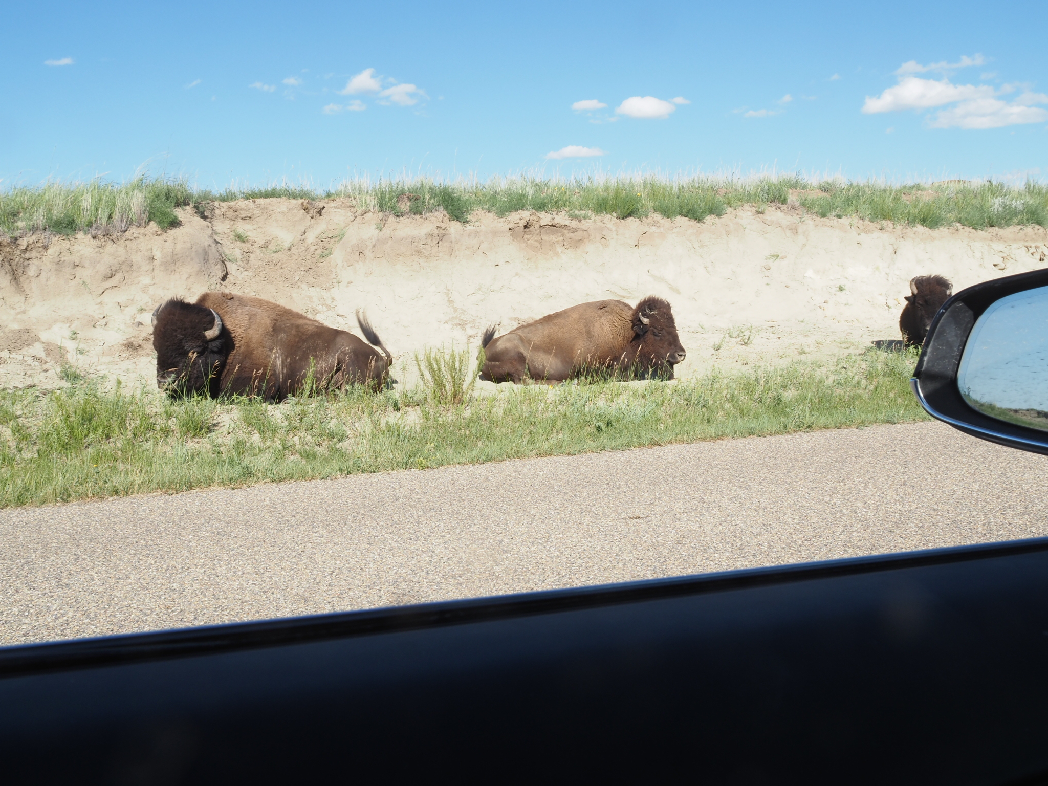
This is the best national park to see buffalos. YelloO Stone and others have them too, but not in the numbers that TRNP has. As I approached Boicourt overlook, buffalos were everywhere walking and lying next to the road. 


The North Section had even more buffalos. I walked down a trail that was supposed to lead me to Little Missouri River following a creek. Soon after, a I passed a prairie dog town. Then I came up on a huge herd of buffalos. I didn't see it as I approached; they were hidden behind a hill. They didn't mind me, however. They went about grazing the grass and chasing flies off their hide.

Caprock Coolie, located in the North Unit, was the main attraction of the second day. It is a loop trail that goes up north from the main road, loops back and cross the road, and then loops back to the starting potin with the view of Little Mo to the south. The first half of the loop through the wood was rather mundane. Then, as soon as you cross the road, you come to the view of Little Mo and spectacular River Bend Overlook. From there, the views are nothing but mundane.

I drove all the way to Oxbow Overlook after I was done with Caprock Coolie for the final view of the Little Mo River.


Monday, July 18, 2022

Rawlins, WY

I turned on the TV, and the first local station that pop was the Channel 31, Denver.  That sure made me feel at home. Rawlins is only 50 miles away from Colorado, equal distance away from Grand Junction and Denver. I can reach out and touch.

It's funny how Colorado feels like home. I've been there only once, and yet I know it like the back of my hand. You see, I crisscrossed it all over, starting at Grand Junction and ending in Denver, when I was there last year. I swept the state from west to east going North and south, from San Juan mountains to RMNP to Sangre de Cristo Mountains. I drove its interstate and backroads alike.

Enough about Colorado. I started out the day with Flaming Gorge in Utah, just 70 miles south of Rock Springs. Then I was back at Rock Springs to charge the car. I was going to sleep on Walmart parking lot there, but I had a long way to go to TRNP. I figured I'd drive another 100 miles and get to Rawlins at least before the night fall. And that's how I ended up at here Rawlins, equidistance away from Grand Junction and Denver.

Wyoming South of Wind River Range is not unlike Utah. The mountains turn into desert covered with sage grass soon after you get out of the dirt road that takes you out of Big Sandy. By the time you get to Flaming Gorge, it becomes bona fide Utah complete with red cliffs and beige rocks, the color of Bryce. The rocks and rivers don't care about boundaries. It is us that drew the line and gave different names to either side as if they are two different places. And our brain is programmed to think different names mean different places and gets surprised when it finds that they are the same.

 Before you get to Flaming Gorge though, you must pass Manila, a green oasis at the foot of Uinta mountains of Utah, a finger sticking out of Wasatch Mountains to the east, kind of like Wind River Range sticking out of Wyoming Rockies. The clouds must be blowing in from the north and dump its moisture before rising above Uinta Mountains.

The Green River originates deep in Wyoming mountains and flows down south, blocked by Wind River Range from flowing East. It then circles Uinta mountains to the east and flows into the vast Utah valley surrounded by Utah and Colorado mountains. There, it merges with the Colorado River in Canyonlands. I saw the confluence there last year. Now I saw it's beginning and journey through flaming gorge and Uinta Mountains. 

What a pleasant place Flaming Gorge was. The plateau above the gorge was populated with pines, firs and junipers. If I had more time, I would've camped at one of many boondocking sites there for a few days and explored the trails and the lake. I only have 12 days now however, to get to New York City. That may not be enough to make stop at TRMP, Minnesota and Wisconsin. I may have to cut something out.


Sunday, July 17, 2022

Cirque of Towers


And to think that mosquitos could have chased me out of the mountains. I was going to hike back out to the trailhead, one day early -- the bugs at Shadow Lake were so bad, I couldn't stand another day. I've seen many lakes like it, and it wasn't worth enduring the mosquito swarm. Then I came over Texas Pass and saw the towers soaring above the basin between the two passes. I had to stop for one more night.

I pitched the tent just below Texas Pass away from the trail with full view of the towers and cliffs from inside my tent. It was possibly the best view site ever. People don't camp there; they usually camp at Shadow Lake, about 10 miles in from the trailhead, and then near Big Sandy Lake, another 10 miles from Shadow Lake. Texas Pass is only a couple of miles from Shadow Lake; it is too short a hike to call it a day. Me, I was going to hike from Shadow Lake all the way back to the trailhead, so stopping at Texas Pass shortened the hike I had to do the next day. 

I went over the ridge to the left after pitching the tent. Lo and behold, there was a snow-covered emerald lake below the ridge. From there it went down the valley for miles with more lakes. I could've day-hiked and explored the valley. But black cloud was coming over the towers and rain drops started to fall. Next time I'll skip Shadow Lake and just camp here, and then explore the valley. 

I came back and took bath in ice water and cold rain. Soon the rain turned into thunder shower. I went into tent and shivered in my sleeping back for 30 minutes and then woke up to the sound of babbling brook next to my tent. 

This is what I thrive in: solitude in nature. I had a similar feeling in Escalante, and now I had the Cirque of Towers all by myself. One was vast desert and the other in towering mountains. What's like to live in the mountains alone, not just for a day, but day after day? I'd like to find out.

Thursday, July 14, 2022

Shadow Lake

The mosquitos are murders. You stop for 30 seconds to take a picture, you get bitten a dozen times. And that's with 40% DEET and head net; you'd be devoured alive without them. The mountains of Wyoming is swell, but I don't think I'll ever hike it again. 

At least the campsite is decent here.  I'm camped on the north side of Shadow Lake near the outlet, under the shade of trees on a level ground above the lake. It took me a little over 6 hours to get here. Not bad for 11 miles. I would've taken more time, but there was no place to escape mosquitos to rest. So I kept walking stopping only for the lunch break at 10:30 by the first lake. I left snacks in the bear canister, and I wasn't going to dig them out. But my Subway lunch was at the top of the pack, so I decided to have early lunch instead.

I braved the mosquitos, went down to the stream near the inlet and bathed. Now I'm no longer sticky. And the air is breezy and pleasant. I'm staying in tent for the rest of the evening, other than to brush teeth and pee.

The trailhead parking lot was almost full when I arrived yesterday evening. Yet I didn't see too many people on the trail. I guess they are spread out on the 25-mile trail. I slept at the trailhead and started out at 8AM. It wasn't unlike the trail to Seneca Lake: unremarkable till past Mam's Lake. Then the soaring peaks appeared and that made braving the mosquitos worthwhile. And Shadow Lake is right underneath the soaring cliffs.  I'm expecting even better view on Texas and Jackass Pass tomorrow.


Tuesday, July 12, 2022

Titcomb Basin, WY

The way out of the Teton and Jackson took me through US-191 along the Snake River, and then Hoback River. The river then veered to southwest at halfway point while the highway continued to southeast to Pinedale. In reality, the Hoback River originates in the southern half of the Teton Range, loops northward and then joins Snake River that flows west to Idaho. I was following the river upstream on US-191.

Pinedale was Stanley of Wyoming. It was not as scenic and no river ran through it. But it was the gateway town to Wind River Range as Stanley was to Sawtooth Mountains. The first thing that greeted me as I drove into it was a ranch set against the mountains just like Stanley.

It was too early for dinner when I got to Wind River Brewing Company where the Tesla charger was located. I wasn't going to eat there anyway. I saw Subway on the way and I was going to buy a foot long sub so that I could have the half of it for lunch the next day. I plugged the car, climbed into the back of my car and researched Wind River Range. Then I drove back to Subway, bought a Black Forest ham sandwich on flat bread and then was on my way to Elkhart Park, the trailhead to Seneca Lake. There were some spectacular views of Fremont Lake and The Wyoming sky along the way and the final vista point presented a full view of the Wind River Range. 

The only plan I had for Wind River Range was Cirque of Towers to the south of Pinedale. But I figured I should do another one while I was in the middle of Wind River Range. The search turned up Seneca Lake as the best hike in Pinedale. Titcomb Basin was on the list too, but it was too far. So, I decided on Seneca Lake, plus a shorter Sacred Rim trail.

I got to the trailhead parking lot and stopped at the visitor center, a small hut further up from the lot. Barbara, the old lady manning the hut, told me that Titcomb Basin past Seneca Lake is what people usually go for. But you need to be prepared for the snow, she said. I didn't know that Titcomb Basin was in the same direction as Seneca Lake. I figured I'll make it to Seneca Lake first and then decide. 

Camp by Seneca Lake

The trail to Seneca Lake wasn't all that exciting, at least till you get to the roaring creek about 2 miles south of it. It was rather claustrophobic, and mosquito infested.  Seneca Lake itself was nice, but nothing stunning. I've seen too many lakes by now to be impressed. I skirted the west side of the lake and found a campsite at the north end of the lake. After pitching the tent, I climbed down 40 feet to the water for bathing and got eaten alive by mosquitos. 5 miles further up was Titcomb Basin.

Titcomb Basin

Next day, I decided to make a daytrip to Titcomb basin. Barbara warned me about getting lost, but all I had to do was to follow the Indian Pass Trail to Island Lake and then switch to Titcomb Basin Trail all the way. She also warned me about creek crossing, but there hardly was any, certainly nothing like the Alice Lake Loop in the Sawtooth Mountains. It was instead galore of ethereal views, first Island Lake and then cascading lakes of Titcomb basin. Absolutely stunning even for someone who is used to alpine lakes all over the Sierra and Colorado.

The day after, I packed out and came back to Pinedale where I spent night at Baymont Hotel. I needed to clean up, rest and prepare for Cirque of Towers, the next destination.


Saturday, July 9, 2022

Grand Teton

The first order of business was to find a campsite. I tried to get to the Shadow Mountain, the only dispersed campground in the Teton, as early as I could, but it was full at the valley level. I had to climb up the dirt road to see if any site was available. I went up quite a way, but all reachable sites were taken. Then I ran into the park employees on an ATV, and they told me one site was open down below. It was in the loop that I skipped on the way up because it appeared unreachable. I went down and went into the loop this time. One site was available indeed and I pitched my tent there. The entry into the campground was all dug up and getting in and out was tricky. But I was able to manage by driving on the edge and the habitat for a week was all set.


Someone, in Wyoming I think, told me that Delta Lake was the absolute best in the Grand Teton. Naturally, it became my first destination. I drove to Lupine Meadow trailhead in the morning, parked on the side of the road -- the parking lot was full -- and set out for 7.4 mile, 2200 feet gain trail to Delta Lake. 

I wasn't in a good shape for some reason. By the time I got to the last half a mile that required scrambling over rocks, I started to black out. It was familiar "heat stroke" except that it wasn't warm, and I wasn't carrying a heavy camera around my neck. It was sunny, however. So, it may be the light sensitivity more than anything else that triggers the "heat stroke". I had to take it slow; I didn't want to faint, fall off the rock and hit my head. I got to the lake at 1:45 PM.


I could see why someone who hadn't seen alpine lakes of the Sierra or Colorado would be so impressed by Delta Lake. But I have seen many of them and the murky water of Delta Lake did not impress me; I was sure this wasn't the best of the Grand Teton. I spent about 30 minutes for lunch and then was back at the trailhead around 4PM. Then I went back to Jackson. I had to get crampons and ice axe to tackle the Grand Teton Loop and the car was getting low on charge. One place that had the crampons wanted exorbitant sum, so I gave up on that. I bought some grocery instead while I was there and then got back to my campsite after 7PM.

After a day of rest, I set out to retrace our route in 2017 from Moran to Moose. Back then, we didn't go into the park; we stayed on Hwy 191 and followed the Reader's Digest Scenic Route from Signal Mountains to Moose. This time, I went up the highway, looped back into the park at Jackson Lake and then drove down to Moose via Jenny Lake. It was an all-day outing, a great photo trip. 

By now, I've been in Teton for 3 days and I'm yet to start the backpacking the Grand Teton Loop, and I was anxious to get that going. I stopped at the Moose Visitors Center to get the permit. The rangers were again adamant that I don't go unless I have crampons and ice axe. I decided to make a daytrip to Hurricane Pass instead.

There was some snow for sure. But it wasn't nearly as much as it was in Sawtooth Mountains. I could've continued on to Alaska Basin fine, except that I didn't bring my backpacking gear with me. I should have in retrospect. I could've come prepared and then turn around if it was impassible. Oh well, live and learn. The trail itself was stunning. It went up the Cascade Canyon following the creek almost all the way. Then it followed the North Fork when it forked at the junction to Paintbrush Canyon. Next time, I should camp at the junction and day-hike to Paintbrush Canyon. Then continue to Alaska Basin and Phelps Lake, making it a 4-day trip.

Near the beginning in the valley, I encountered a moose which for some reason I thought was a statue. I must've been thinking about the statues in Jackson on the roadside. I stopped only when I was within 10 yards of it. I took some photos and quietly move on.


I started the 24-mile trekking at 5AM, got to the Hurricane Pass around 1PM, and finished at 7PM. It was the longest day hike I've ever done to date.

The next day I went to Jackson again for lunch at Chinatown Restaurant, fill the water and fill the car. After a day of rest, I was on Death Canyon trail to Alaska basin this time. Death Canyon also followed a creek all the way to the Death Canyon Barn. Then it climbs up to the peak on the way to Alaska basin. The trail was exposed and rather boring at that point. So I came back to the Barn and continued on the death Canyon trail. It was shaded, and mosquito-ed, but wasn't that exciting either. After a few miles, I turned around and came back out. After that, I was out of the Tetons and on my way to Pineapple.